
France's soils hit September drought record as dry weather threatens autumn crops


France's soils have hit a September dryness record, Meteo-France said, with 84% of the country experiencing decennial drought on September 20, meaning conditions expected on average once in ten years for that month.
France recorded only one day with national rainfall above 1 mm from September 1 to the September 22 bulletin, on September 8. Paris-Montsouris last recorded significant rain on August 29 and Nice on August 24. Totals along the Channel were around 10 mm, locally 20 mm, against 60-70 mm for a normal full September. The southern third had 5-10 mm, rising to 20 mm over higher ground.
The drought threatens autumn pasture growth, groundwater recharge and sowing for the 2027 harvest. European farmers were already warning of widespread crop failures after this summer, and continued dry weather could complicate planting for the next harvest.
"I no longer have the words to describe what is currently happening in France," wrote agro-climatologist Serge Zaka on September 21 in a post translated from French. Forecasts keep pushing back the return of rain, he said, with almost no significant precipitation expected across much of the country until October 6, and France's soil moisture index potentially set to break an all-time drought record "previously held only in the heart of the most extreme summers" - except that this time it would fall in late September or early October.
"And meanwhile, no respite for our forests, our ecosystems, and our agriculture," Zaka wrote. "The soils continue to dry out, plants accumulate stress, and the consequences now stretch far beyond the summer. And this has been going on since May."
The European Centre for Medium-Range Weather Forecasts' September 21 model run projects little precipitation across much of France over the 360 hours to October 6. White areas mark the lowest totals, while blue shading indicates higher totals in some regions. This is a single model forecast, not a guarantee of no rain or evidence by itself of the atmospheric mechanism.
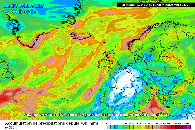
Forecast accumulated precipitation over 360 hours from the ECMWF 00Z run of September 21, 2026, valid at 02:00 local time on October 6. Much of France has low totals, with regional variation. Source: Meteociel / ECMWF.
Most of the country is already on restriction
Ninety-three departments were under water restriction orders by September 10 and 74 of them were at crisis level, the highest of the four steps, according to Meteo-France. Crisis means a blanket ban on drawing water for field crops, with narrow night-time windows kept for market gardening, nurseries and young vines, and exemptions only for livestock.
Groundwater is in no better shape. The Bureau de Recherches Geologiques et Minieres found 61% of monitoring points below their monthly normal on September 1, with the basement aquifers of the Limousin, the Jura limestones and the northern Alsace plain rated very low. Those are fast-reacting aquifers that live off winter rain, and the recharge season is meant to have started.
The dryness is not simply a rainfall story. National cumulative rainfall to September 13 was about 470 mm against a normal 530 mm, a shortfall of roughly 11%, yet the soils are drier than in 2022, when the same date had seen only 417 mm. The difference is heat: summer 2026 was the hottest on record in France and the second driest, and evaporation has pulled water out of the ground faster than the rain gauge suggests, Meteo-Paris noted.
The sowing window is closing
The maize harvest now coming in is the smallest in nearly half a century. Agreste, the agriculture ministry's statistics arm, put the 2026 grain maize crop at 9.0mn tonnes on a yield of 70.3 quintals per hectare across 1.28mn hectares, a 34% fall from 13.7mn tonnes in 2025 and the weakest since 1980. Traders are working on numbers below that, with some analysts talking about under 7mn tonnes.
Rapeseed is the more urgent problem, because it has to be sown now. Growers treat September 15-20 as the cut-off for getting the crop up before flea beetle arrives, and much of the seedbed work is done with nothing drilled into it. Terres Inovia, the oilseeds institute, reckons a minimum of 15 mm of rain is needed to trigger emergence in a prepared seedbed and 30-40 mm where conditions are less kind; the ECMWF chart projects little rain across much of France. Farmers in the Marne told Terre-net their fields had not been touched since harvest.
Soft wheat goes in from October, and it goes into the same soil. That is the crop that decides whether France remains the European Union's largest wheat exporter, and it is being planted into a bed with no moisture reserve beneath it. British growers spent August saying they could not afford to plant next year's crops at all, and a second European planting failure would land on grain markets already carrying a food price shock from the closure of Black Sea ports.
Pasture is the loss nobody counts. Grass has not regrown since the spring cut in much of the country, so livestock farmers have been feeding winter forage since the summer and will reach November with the barn already half empty.
Forests that have already burned once
More than 115,000 hectares of French forest had burned by late July, interior minister Laurent Nunez said, the worst fire season since 1949. The Gironde fire alone took over 42,000 hectares and forced roughly 250,000 people out of the Gironde and the Landes, and more than 2,000 hectares went at Fontainebleau, on the edge of Paris, where large forest fires are not supposed to happen.
Across the EU, 505,683 hectares had burned by August 5 against 379,392 a year earlier, the European Commission's Joint Research Centre reported on August 12. France and Spain accounted for much of it. The fire season would normally be winding down by late September as the rains arrive; with fuel moisture still falling, the Mediterranean south and the southwest stay live into October.
Forests that survived the summer are not out of it either. Trees under a fifth straight month of water stress shed leaves early, stop laying down wood and become easier prey for bark beetle, and the damage shows up in mortality figures two and three years later rather than this autumn.
Rivers, reactors and the power the drought takes
France runs the largest nuclear fleet in Europe on river water, and the rivers are the constraint. EDF confirmed weather-related production cuts this summer at Bugey and Tricastin on the Rhone and at Golfech on the Garonne, where a reactor was stopped as the river approached its regulatory temperature ceiling, The Connexion reported. The limits protect aquatic life rather than the reactors, but the megawatt-hours are lost either way.
Hydropower goes the same way and does not come back quickly. French hydro plants generated 2,477 GWh in September 2022, the last comparable drought autumn, the weakest September in the IEA's monthly series back to 2010 and a third below the 3,759 GWh of September 2025. Reservoirs entering October empty set the following winter's output, which is when France needs the flexibility most.
Four major European rivers - the Loire, the Po, the Rhine and the Danube - all hit record lows in August, the Joint Research Centre found. Bulgaria had to cut output at Kozloduy as the Danube fell to a record 31 cm, and on the Rhine the Kaub gauge dropped below 30 cm against an all-time low of 25 cm set in October 2018, leaving tanker barges loading a tenth to a fifth of capacity and freight from Rotterdam to Karlsruhe up from €45 a tonne in late June to €130-140, Breakbulk News reported. A rise in August briefly eased pressure on German refineries; another dry month would take that back.
A continental block, not a French one
Half of EU and UK territory was under some level of drought in late July and 9% was at alert level, where vegetation is visibly stressed, the Joint Research Centre reported, naming France, Germany, Hungary, Romania and the UK as the worst affected. The mechanism is a run of blocking anticyclones parked over western Europe, shunting Atlantic depressions north towards Scandinavia and south into the Mediterranean and leaving the middle dry, which is exactly what the ECMWF chart draws.
The same jet stream that is starving France of rain was dumping it elsewhere a month ago, when severe storm risk built over France, Switzerland, Belgium and western Germany in late August. A blocked pattern does not produce less weather, it produces the wrong weather in the wrong place, and it is the signature of the disaster season that has become an annual fixture rather than an anomaly.
The wider picture is of shrinking water reserves from Central Asia to the Alps. Continued dry weather would prolong pressure on French agriculture and water supplies into autumn.
Unlock premium news, Start your free trial today.


